Flight models Average Day frozen Phase 5A provisional
What exists in your archive for the path and endpoint side, with its status. I did not run or rank anything here.
Average Day model frozen, packaged 3 Oct 2026
Flies one commanded flight from the 19:41:03 arc-1 start through ERA5 weather with a Boeing 777-200 performance model, scores it against 4 BTO and 5 BFO residuals to 00:11 UTC, and tracks fuel. I ran its verify.py here: all three stored reference flights reproduce (chi² within 1e-11, 00:11 positions and fuel exact). Tracks below are those flights re-flown at dt 7.5 s.
Reach vs fuel-matched speed
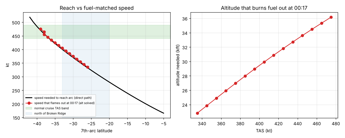
Your figure. The black line is the speed needed to reach the arc on a direct path. Red points are the speeds at which fuel runs out at 00:17 with altitude solved.
Terminal points vs surveyed seabed
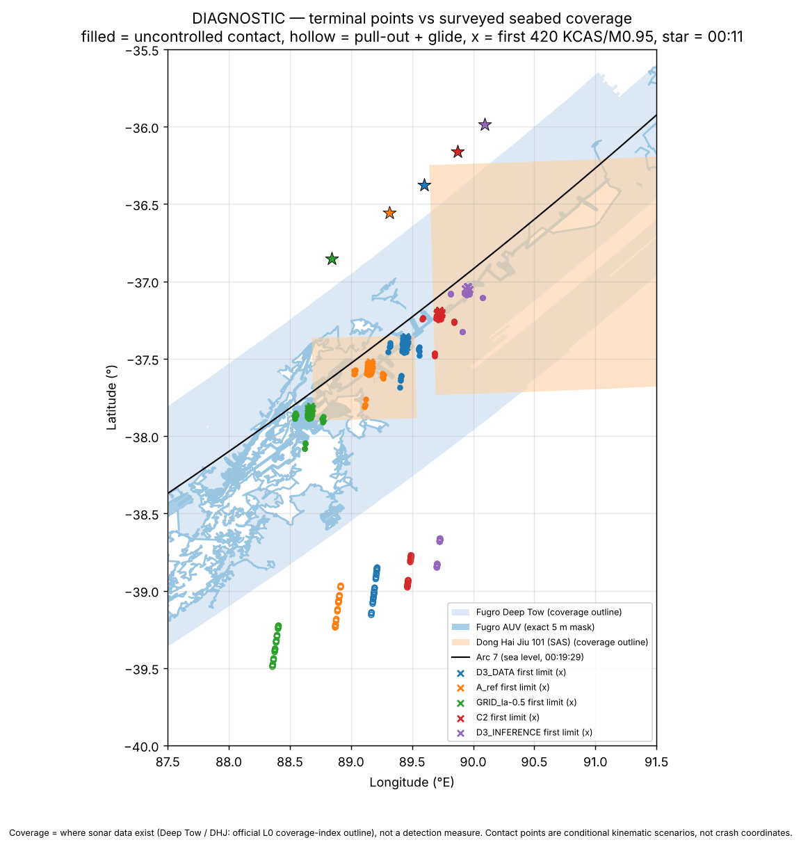
Your figure. Coverage is where sonar data exist, not a detection measure. Contact points are conditional kinematic scenarios, not crash coordinates.
Known limits (package README)
- Score stops at 00:11 UTC; nothing after is modelled beyond fuel.
- SDU pre-compensation keeps zero vertical speed (K-mode open).
- ERA5 is clamped east of 102.4°E; temperatures above 300 hPa are held at their 300 hPa values.
- One-engine fuel burn may be too generous at altitude (about FL370 at M0.60 against FL290 in the ATSB figure).
- Fuel is one tank feeding both engines.
High-Fidelity Average Day Solver: nominal startup and route-box diagnostics TASK_021, conditional
Replays of the saved flights with the force model, nine-term score (4 BTO, 5 BFO), fuel profile and k bounds fixed. Both solves start from the P038_C commands. The score stops at 00:11.
| Case | χ² | Δχ² vs U | k | Loss time | Gap to log-on | Position at 00:11 | Fuel at 00:11 | Status |
|---|---|---|---|---|---|---|---|---|
| P038_U (reference) | 7.4948 | – | 1.02689 | 00:14:08 | 320.7 s | −36.526, 89.353 | 301.9 kg | reference |
| P038_C | 7.9141 | +0.419 | – | 00:16:29 | 179.9 s | −35.901, 90.327 | 516.6 kg | guard False |
| C120 | 8.1171 | +0.622 | 1.024738 | 00:17:14 | 134.9 s | −35.848, 90.393 | 585.0 kg | passed guard, stationarity, verification |
| C-box | 7.7633 | +0.269 | 1.024738 | – | 179.9 s | −36.161, 89.917 | 517.6 kg | solve failed (stalled); flight verified |
- C120 costs +0.62 in χ² against the unconstrained solve, so within this diagnostic it does not depend on a slow startup. It is 8.3 km from P038_C and 119.9 km from P038_U.
- It is constrained, not a free optimum. Nine constraints are active, including k at its lower bound, start latitude at its 0.5° limit and a fuel allowance margin of about 0.1 kg.
- C-box did not converge (15 accepted iterations). It moved 46.9 km from P038_C, which triggers the box-shaping rule. It cannot separate the bound widening from extra optimisation of a reference that was not stationary.
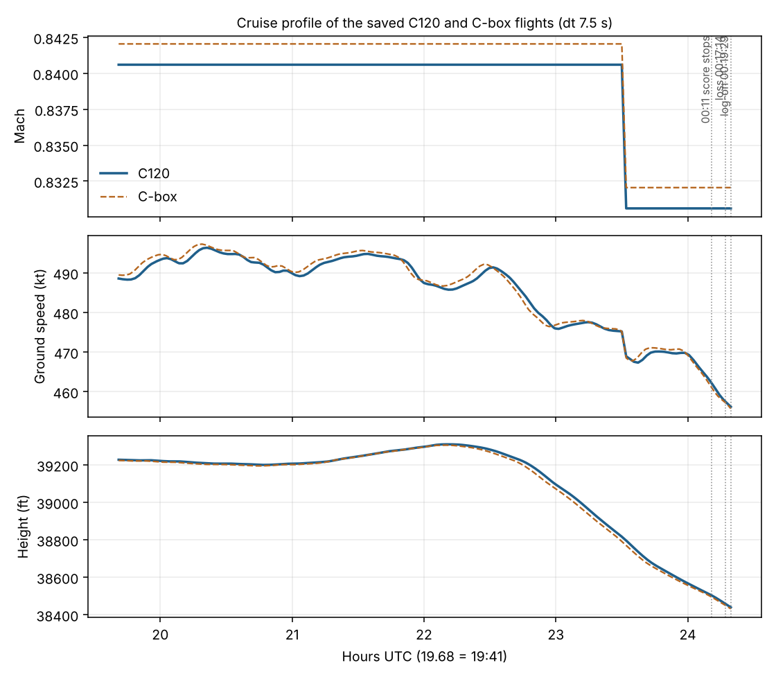
C120 cruise profile
| Time UTC | Lat, lon | Ground speed | Track | Height |
|---|---|---|---|---|
| 19:41:03 | 0.500, 93.754 | 251.3 m/s (489 kt) | 184.6° | 11,957 m (39,227 ft) |
| 20:41:05 | −7.719, 93.092 | 253.5 m/s | 184.7° | 11,949 m |
| 21:41:27 | −15.967, 92.401 | 254.2 m/s | 184.8° | 11,969 m |
| 22:41:22 | −24.097, 91.660 | 250.7 m/s | 185.1° | 11,959 m |
| 00:11:00 | −35.848, 90.393 | 237.7 m/s (462 kt) | 185.7° | 11,736 m (38,502 ft) |
Mach 0.8406 at the start falling to 0.8306 at 00:11; pressure constant at 214.2 hPa; temperature 223.5 K to 219.2 K; no turn above 1°/min; path length 4,179 km (2,190 nm) from 19:41 to 00:11. C-box is similar (Mach 0.8420 to 0.8320, track 185.2° to 186.5°, path 4,183 km).
TASK_022: terminal continuations of C120 bounded experiment, conditional
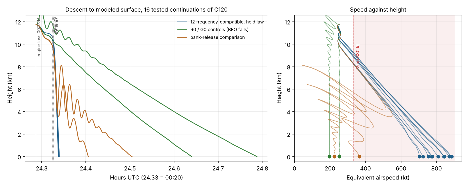
582 searched histories from C120’s own engine-loss state, six matched strata (E+ and E− at ΔCD 0, 0.005, 0.015), eight shared seeds. C120 itself was frozen: no parent, fuel, k or engine-loss change. Fitting stops at 00:19:37; the continuation to the surface is then held fixed, not fitted to any location.
The central result
Twelve histories reproduce the final frequency pair. Every one of them reaches the water supersonic, far outside the airframe envelope, inside the aerodynamic proxy the model flags as unsupported. The two controls that stay inside the supported aerodynamic domain and arrive at survivable speed miss the 00:19:37 BFO by more than 100 Hz.
| Group | Final BFO pair | Mach at surface | EAS at surface | Descent rate | Aerodynamic domain |
|---|---|---|---|---|---|
| 12 fitted, held law | compatible | 1.06 – 1.33 | 704 – 885 kt | 36,700 – 78,000 ft/min | parabolic proxy (unsupported) |
| R0, G0 controls | fail by 28–48σ | 0.31 – 0.38 | 198 – 252 kt | 1,100 – 1,500 ft/min | clean surrogate (supported) |
| 2 bank-release comparisons | compatible to release | 0.34, 0.55 | 225, 364 kt | 1,700, 4,900 ft/min | parabolic proxy |
A 777’s Vmo is 330 kt and Mmo 0.87. The fitted contacts arrive at 2.1 to 2.7 times Vmo, banked 76° to 89°. Impact states read from each saved contact trajectory.
What the signals actually say
- The BTO is not a miss. The reported residuals of −24.98 to −26.69 µs are 0.86 to 0.92σ against this project’s own listed σBTO of 29.0 µs. All twelve sit inside one standard deviation. The 1 µs target in the brief was about 0.03σ, roughly thirty times tighter than the measurement, and was declared as a numerical search target rather than an acceptance rule.
- The BTO is inherited, not fitted. Across six strata, both bank signs, three drag values and 582 histories, the residual spans 1.71 µs, about 256 m of range. It is set by the frozen C120 state at 00:11 and the terminal law cannot move it, so the 00:19:29 timing gives no discrimination among terminal laws here. Nothing was drawn toward the arc: the model sits a consistent 3.7 km of range away from it.
- One case is clean. S03 (E−, ΔCD 0) needs no warm-up offset at all: BFO29 0.85σ, BFO37 −1.72σ, BTO29 −0.90σ, all within 2σ. The other nine warm-up cases rely on a shared offset anywhere in 17 to 136 Hz, permissive enough to absorb raw residuals of 10 to 67 Hz. S07 and S11 also need no offset but sit at 2.35σ and 5.75σ on BFO29.
G0 control: contact resolved
G0 was horizon-limited at 00:45 in the original run. A follow-up addendum continued the same state with unchanged physics and no refitting. It reaches the surface at 00:47:16 UTC, 38.7059°S 90.4148°E, 1,802 s after engine loss, after 230.3 km of ground path from 11.72 km — a glide ratio near 19.6:1, realistic for a clean 777. It arrives at 198 kt EAS and 1,091 ft/min. The two finest meshes agree to 0.02 m and 7 µs against targets of 100 m and 1 s. Its frequency mismatch is unchanged: it remains a control, not a candidate.
Spread across tested assumptions
| Outcome | Signed distance to the arc ring (my fit) |
|---|---|
| 12 fitted contacts, held law | +1.4 to −6.6 km |
| Bank-release comparisons | −41 and −46 km |
| R0 control | −141 km |
| G0 control | −167 km |
Positive is inside the ring. G0’s contact lies about 199 km from the fitted cluster, so the spread across tested assumptions is of order 200 km, not the 13 km seen within the held-law group. Distances use my circle fit to the reference arc, which is a 40,000 ft reference compared here against sea-level contacts; they indicate position, not a BTO residual.
TASK_026: how much rests on the BFO convention complete, 6 Oct
The compensation convention was swept with a diagnostic coordinate κ, the fraction of the aircraft’s vertical Doppler removed by the SDU pre-compensation. κ = 0 is the convention in use; κ = 1 makes the BFO insensitive to vertical speed. The sixteen frozen message states were re-scored across the range; no trajectory was re-integrated and no κ was fitted or preferred.
The premise was wrong: the convention is published
Holland (arXiv 1702.02432v2), sections IV-A and IV-B, describes the SDU calculation as using ground speed and track, zero vertical speed, nominal satellite position and sea-level aircraft position, with the physical Doppler term separately carrying actual vertical motion. That is the convention the model uses. It is documentary support rather than inspected SDU firmware, but it is not an undocumented choice.
The “K-mode OPEN” label that prompted this check turns out to concern historical callers that forced the physical up velocity to zero, and an unavailable cross-lineage specification. The current call path passes physical local up and has no such switch. Earlier wording on this page treated that label as evidence the compensation convention was unvalidated. It was not.
The sweep does not invert the result — it empties it

- All twelve fitted histories keep at least one compatible hypothesis up to κ = 0.042. The last warm-up-compatible one ends at κ = 0.269, and the last compatible history of any kind at κ = 0.317. Above that, nothing in the retained set is compatible.
- R0 and G0 never become compatible anywhere in [0, 1], under any of the four geometry switch combinations. There is no value of κ at which a glide control works.
- So the sensitivity runs from “dives match” to “nothing matches”, never to “glides match”. The positive half of the TASK_022 reading is fragile beyond about κ = 0.32. The negative half — that these particular controls fail — holds across the whole domain.
- The original operator reproduces to 4.5×10⁻¹³ Hz, and the BTO is untouched by κ, so TASK_022’s timing residuals are unchanged.
The cruise score is not flat, but it cannot choose
I expected the nine cruise terms to be blind to κ and predicted a circularity argument from that. The curve is measurably non-flat: χ² moves from 8.117071 to 8.119623 across the full range, a span of 0.00255, with a largest BFO change of 0.116 Hz against a listed σBFO of 4.3 Hz. Codex declined to draw the identifiability conclusion I had anticipated, which was the right call: the claim that the cruise data carry no information is not established. In practice a 0.0026 spread in χ² cannot discriminate between conventions, but that is a statement about resolving power, not about information being absent.
The 18:25 log-on, as observed
| Seconds after log-on | 0 | 7 | 97 | 97 | 101 | 159 | 168 |
|---|---|---|---|---|---|---|---|
| BFO (Hz) | 142 | 273 | 176 | 175 | 172 | 144 | 143 |
Holland identifies the first burst as unreliable on signal quality. Excluding it, the sequence decays by 130 Hz over 161 s — a real excess-then-decay shape of about the magnitude the warm-up envelope allows (17 to 136 Hz). It is not an independent calibration: the raw differences also contain motion, geometry and channel effects, and this event already contributed to the published envelope, so reusing it would reuse evidence. The envelope was not narrowed. Six other log-ons exist in the literature but their burst samples are not in the archived copy.
TASK_029: why every flight lands near 36°S coarse pilot, 1% of grid
Seven solutions in this family arrive at 00:11 between 35.85°S and 36.85°S. A forward sweep tested whether anything further north is reachable: commanded inputs swept, 00:11 latitude recorded as an output, no optimiser, no target latitude.
Fuel was never the obstacle. The handshake sequence is. Four sampled commands reach 23.9°S to 26.4°S still powered at 00:11, holding 2.3 to 3.0 tonnes. Their nine-term χ² is 2,507 against C120’s 8.117.
| Handshake | z² | Residual | Range error |
|---|---|---|---|
| 21:41 BTO | 855.4 | 29.2σ | ~127 km |
| 00:11 BTO | 829.8 | 28.8σ | ~125 km |
| 20:41 BTO | 614.5 | 24.8σ | ~108 km |
Range errors are mine, converted from the squared residuals at the listed σBTO of 29 µs.
- The mechanism. The ring radii grow through the night at a rate set by ground speed. A flight slow enough to finish north cannot match how fast they expanded earlier. The 00:11 arc alone permits a northern crossing; the sequence of four does not.
- They fail the chronology too, from the other side. Those four are still powered at 00:25, so they never flame out near 00:17 and cannot produce the 00:19 log-on. Four faster commands exhaust before 00:11. Northern reach and a 00:17 flameout are mutually exclusive in this family.
- The 19:41 BFO improves sharply: 0.031 against C120’s 2.901, with 44 initial states beating C120 on the model’s largest single misfit. Every one of them fails later, so this is an observation about one term, not a fit.
- Incoming leg clears everything: 631 to 843 km from the 18:22 derived radar position, 259 to 346 kt implied, turns of 5° to 67° left. Recorded for every grid point, never used to filter or rank.
- One hypothesis retired. The package README warns that one-engine fuel burn may be too generous, which would add range and push the endpoint south. The evaluator has no single-engine phase at all — fuel is one tank feeding both engines — so that warning does not apply here and the sensitivity is unassessable.
TASK_030: the full arc-1 sweep, and what it exposed complete, 7 Oct
1,008 commanded flights across 21 arc-1 start points spanning 6°S to 14°N, four bearings, four Mach values, three pressure levels, screened at dt 15 s with every reported profile rerun at 7.5 s. All 21 starts retained; initial-locus BTO residual 1.16×10⁻¹⁰ µs.
WEATHER_HORIZONTAL_OR_TIME_DOMAIN; starts north of 10°N produced no finite history; and the per-start minima piled up at 29.2–31.6°S, which is the edge of the data rather than an optimum. Earlier wording on this page read the northern result as a physical exclusion. It is a coverage limit.The arc segment nobody could model and nobody has searched
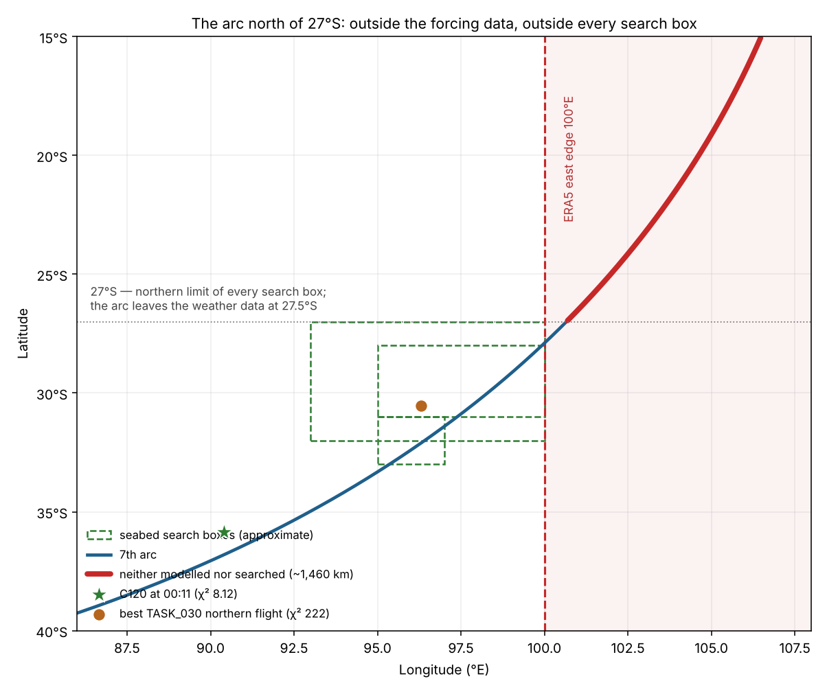
The northern limit of every search box in your manifest is 27°S. The arc leaves the weather data at 27.5°S. Those two boundaries fall within half a degree of each other, leaving roughly 1,460 km of arc, from 27°S to 15°S, that is outside the model's forcing and outside all recorded seabed coverage.
That coincidence is not mysterious. The ERA5 subset was evidently clipped to the region the search already assumed. The consequence is that the model has never been able to challenge the assumption that defined its own inputs.
What the sweep found where it could look
| Result | Value |
|---|---|
| Rows with all nine score terms | 267 of 1,008 |
| Powered and force-supported through 00:11 | 48 |
| Meeting the declared joint score and fuel bands | 0 |
| Best powered record (start 3°N) | χ² 221.7 at 30.53°S, 96.30°E, 2,643 kg remaining |
| Lowest geometric score (start 6°N) | χ² 112.3 at 31.37°S — fails buffet at the start, not a feasible flight |
| Rows improving C120's 19:41 BFO term (2.901) | 460, of which 48 have supported powered histories |
| Range of verified powered 00:11 latitudes | 24.58°S to 35.48°S |
The sweep points north, and the absolute scores are not the signal
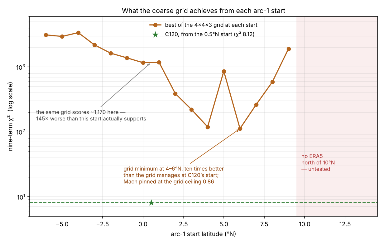
The grid used bearings {140, 158, 176, 195}°, Mach {0.55, 0.65, 0.75, 0.86} and pressures {200, 260, 320} hPa. C120 flies bearing 184.6° at Mach 0.8406 falling to 0.8306 — a schedule, not a constant — at 214.2 hPa, and so misses the grid on all three axes.
- Every per-start minimum chose bearing 176°, the grid value nearest C120’s 184.6°. Bearing resolution is 18°, so the optimum bearing is unresolved at every start.
- The best Mach climbs monotonically with start latitude — 0.55, 0.65, 0.75 — and is pinned at the grid ceiling of 0.86 for every start from 6°N north. The grid wanted to go faster than it was allowed to. Mmo is 0.87.
- 460 rows improve C120’s 19:41 BFO term of 2.901, the model’s single largest misfit, 48 of them with supported powered histories.
- The trend was still interesting where the data stopped. Starts north of 9°N produced no finite history at all, because ERA5 ends at 10°N.
Read together, this is a positive indication of plausible northern arc-1 starts, not an absence of them. A start at which a 145×-handicapped grid still reaches 112 is a start that may well support a fit in C120’s territory once bearing, Mach and pressure are resolved properly. That is a hypothesis the data suggests and the model cannot currently test.
The start was never observed
Part A confirmed that C120's 0.5°N initial latitude is a fitted latitude-box boundary, not an observed latitude; its longitude is then constructed from the 19:41 BTO given that latitude, pressure and datum. The 19:41 BTO is not among the four scored BTOs. Every flight in the family inherits that start, C120 included.
Three coverage limits, all in the same direction
| Limit | Consequence |
|---|---|
| Grid cannot represent C120’s commands | Absolute χ² is uninformative; no start can be fairly compared with C120 |
| ERA5 ends at 10°N | Starts north of 9°N have no history, and the trend was still improving |
| ERA5 ends at 100°E; arc crosses it at 27.5°S | The endpoints northern starts would reach cannot be scored at all |
Every one of these truncates the same hypothesis, and none of them is a physical result.
Next: extending ERA5 east to 120°E and north to 20°N is a data acquisition task, not a modelling one, and is the only thing that makes the northern question askable. Until then, no amount of computation can answer it. Directive 19 specifies that acquisition, with an overlap gate so a 2026 download is not silently spliced onto a 2014-vintage subset.
Phase 5A candidates Aug 2026 snapshot
97 candidates (96 labelled final handshake position, 1 prior diagnostic coordinate). Search status for all 97 is unknown; the file notes that unknown is not converted to unsearched.
BTO-only survivors Jun 2026
12 terminal-dynamics diagnostic rows from 3 families in one region. selected_as_best and final_coordinate_produced are false for all 12.
Radar and search sourced
One measured radar point (IGARI last SSR, 17:21:13 UTC). The 18:22:12 primary radar report has no coordinates. Search boxes are approximate bounding boxes from your manifest.
Candidates and the 7th arc
Phase 5A candidate table
Scores are the snapshot's own columns. The satcom score here is that engine's value, not the frozen v06 scorer's. Distance to the reference arc is computed in this page from the arc file's vertices (nearest point, so slightly overstated between vertices). Click a column to sort.
BTO-only terminal survivors (June)
Initial parameters are at the start of the path family; terminal values are at 00:19:29 UTC.
Known caveats in the sources
- The point 34.86°S, 93.107°E at 36,603 ft appears in candidate-derived geometry. Its BTO bias is observed minus geometry at that point, so a zero residual there is circular and it is not a calibration benchmark (June candidate-state file).
- Prior diagnostic coordinate in Phase 5A: 31.397°S, 90.403°E.
- Height datum: geopotential height treated as ellipsoidal height may matter, per your notes. I have not tested it here.